Lithgow · council area
Needs action
No Emergency Warnings or Watch and Act alerts right now.
Show map of Lithgowabout 20 KB · loads only when opened▾ Hide map
Map preview · about 20 KB · © OpenStreetMap
Current items by layer
Nothing current for Fire, Burn areas, Earthquakes or SharkSmart.
Live flood data for New South Wales isn't available here yet
Live weather data for New South Wales isn't available here yet
Live water supply data for New South Wales isn't available here yet
Live algal blooms data for New South Wales isn't available here yet
Live dams data for New South Wales isn't available here yet
Live other data for New South Wales isn't available here yet
Roads 16
Level: All levels · Emergency Warning · Watch and Act · Advice
Changed traffic conditionsChanged Traffic Conditions — Hartley Vale Road, Hartley ValeHartley Vale Road At Darling Causeway, Hartley Vale · NSW ·
Show map of Changed Traffic Conditions — Hartley Vale Road, Hartley Valeabout 20 KB · loads only when opened▾ Hide map
Map preview · about 20 KB · © OpenStreetMap
Expect delays · Plan your journey · Use an alternative route
Updated 29 Oct, 7:45 am AEDT · -33.5392, 150.2606
HazardHazard Roadway Blocked — Wolgan Road, LidsdaleWolgan Road At Wolgan Gap, Lidsdale · NSW ·
Show map of Hazard Roadway Blocked — Wolgan Road, Lidsdaleabout 20 KB · loads only when opened▾ Hide map
Map preview · about 20 KB · © OpenStreetMap
Avoid the area · Plan your journey · Delay non-essential travel
Updated 29 Oct, 7:43 am AEDT · -33.3165, 150.1115
Changed traffic conditionsChanged Traffic Conditions — Browns Gap Road, HartleyBrowns Gap Road Between Hartley Valley Road And Hassans Walls Road, Hartley · NSW ·
Show map of Changed Traffic Conditions — Browns Gap Road, Hartleyabout 20 KB · loads only when opened▾ Hide map
Map preview · about 20 KB · © OpenStreetMap
Check signage · Reduced speed limit · Follow directions on site
Updated 29 Oct, 7:40 am AEDT · -33.5078, 150.1812
Special eventLithgow Halloween Festival 2026 — Chifley Road, LithgowChifley Road, Lithgow · NSW ·
Show map of Lithgow Halloween Festival 2026 — Chifley Road, Lithgowabout 20 KB · loads only when opened▾ Hide map
Map preview · about 20 KB · © OpenStreetMap
Exercise caution · Check signage · Reduce your speed
Updated 26 Oct, 12:11 pm AEDT · -33.4783, 150.1699
Scheduled roadworkScheduled Roadwork — Chifley Road, LithgowChifley Road Between Lithgow And Bell, Lithgow · NSW ·
Show map of Scheduled Roadwork — Chifley Road, Lithgowabout 20 KB · loads only when opened▾ Hide map
Map preview · about 20 KB · © OpenStreetMap
Allow extra travel time · Reduced speed limit · Exercise caution
Updated 26 Oct, 10:38 am AEDT · -33.4769, 150.1847
Adverse driving conditionsHazard — Great Western Highway — Mount VictoriaMount Victoria · NSW ·
Show map of Hazard — Great Western Highway — Mount Victoriaabout 20 KB · loads only when opened▾ Hide map
Map preview · about 20 KB · © OpenStreetMap
Event: Hazard Type: Adverse driving conditions Road: Great Western Highway Location: Mount Victoria Description: EMERGENCY ROADWORK Road damage MOUNT VICTORIA Great Western Highway at Victoria Pass…
Updated 26 Oct, 3:05 am AEDT · -33.5814, 150.2332
Emergency roadworkEmergency Roadwork Road Damage Mount Victoria Great Western Highway At Victoria PassGreat Western Highway At Victoria Pass, Mount Victoria · NSW ·
Show map of Emergency Roadwork Road Damage Mount Victoria Great Western Highway At Victoria Passabout 20 KB · loads only when opened▾ Hide map
Map preview · about 20 KB · © OpenStreetMap
Use an alternative route · Plan your journey · Allow extra travel time
Updated 26 Oct, 3:04 am AEDT · -33.5814, 150.2332
Changed traffic conditionsChanged Traffic Conditions — Portland Sunny Corner Road, PortlandPortland Sunny Corner Road Between Sunny Corner Road And John Mackey Drive, Portland · NSW ·
Show map of Changed Traffic Conditions — Portland Sunny Corner Road, Portlandabout 20 KB · loads only when opened▾ Hide map
Map preview · about 20 KB · © OpenStreetMap
Allow extra travel time · Exercise caution · Expect delays
Updated 23 Oct, 3:46 pm AEDT · -33.4036, 149.9156
Scheduled roadworkScheduled Roadwork — Sodwalls Road, SodwallsSodwalls Road, Sodwalls · NSW ·
Show map of Scheduled Roadwork — Sodwalls Road, Sodwallsabout 20 KB · loads only when opened▾ Hide map
Map preview · about 20 KB · © OpenStreetMap
Allow extra travel time · Expect delays · Exercise caution
Updated 23 Oct, 3:41 pm AEDT · -33.5208, 149.9693
Changed traffic conditionsChanged Traffic Conditions Load Limit — Main Street, LithgowMain Street Between Lithgow Street And Clwydd St, Lithgow · NSW ·
Show map of Changed Traffic Conditions Load Limit — Main Street, Lithgowabout 20 KB · loads only when opened▾ Hide map
Map preview · about 20 KB · © OpenStreetMap
Expect delays · Allow extra travel time · Use an alternative route
Updated 23 Oct, 3:41 pm AEDT · -33.4827, 150.1528
Scheduled roadworkScheduled Roadwork Resurfacing — Magpie Hollow Road, South BowenfelsMagpie Hollow Road At Sir Thomas Mitchell Drive, South Bowenfels · NSW ·
Show map of Scheduled Roadwork Resurfacing — Magpie Hollow Road, South Bowenfelsabout 20 KB · loads only when opened▾ Hide map
Map preview · about 20 KB · © OpenStreetMap
Allow extra travel time · Exercise caution · Expect delays
Updated 23 Oct, 3:40 pm AEDT · -33.5097, 150.1067
Changed traffic conditionsChanged Traffic Conditions Load Limit — Gas Works, LithgowGas Works Between Clwydd Street And Chifley Road, Lithgow · NSW ·
Show map of Changed Traffic Conditions Load Limit — Gas Works, Lithgowabout 20 KB · loads only when opened▾ Hide map
Map preview · about 20 KB · © OpenStreetMap
Check signage · Plan your journey · Use an alternative route
Updated 23 Oct, 3:39 pm AEDT · -33.4764, 150.1717
Traffic cameraJenolan Caves Road (Hampton)Hampton · NSW
Show map of Jenolan Caves Road (Hampton)about 20 KB · loads only when opened▾ Hide map
Map preview · about 20 KB · © OpenStreetMap
Jenolan Caves Road at Duckmaloi Road looking north towards Sydney.
-33.6768, 150.0509
Details OpenStreetMap Source (Data © Transport for NSW (Live Traffic NSW).)
Traffic cameraGreat Western Highway (Lithgow)Lithgow · NSW
Show map of Great Western Highway (Lithgow)about 20 KB · loads only when opened▾ Hide map
Map preview · about 20 KB · © OpenStreetMap
Great Western Highway at Main Street looking north towards Bathurst.
-33.4813, 150.1369
Details OpenStreetMap Source (Data © Transport for NSW (Live Traffic NSW).)
Traffic cameraMort Street (Lithgow)Lithgow · NSW
Show map of Mort Street (Lithgow)about 20 KB · loads only when opened▾ Hide map
Map preview · about 20 KB · © OpenStreetMap
Facing east towards Sydney.
-33.4811, 150.1614
Details OpenStreetMap Source (Data © Transport for NSW (Live Traffic NSW).)
Traffic cameraGreat Western Highway (Victoria Pass)Victoria Pass · NSW
Show map of Great Western Highway (Victoria Pass)about 20 KB · loads only when opened▾ Hide map
Map preview · about 20 KB · © OpenStreetMap
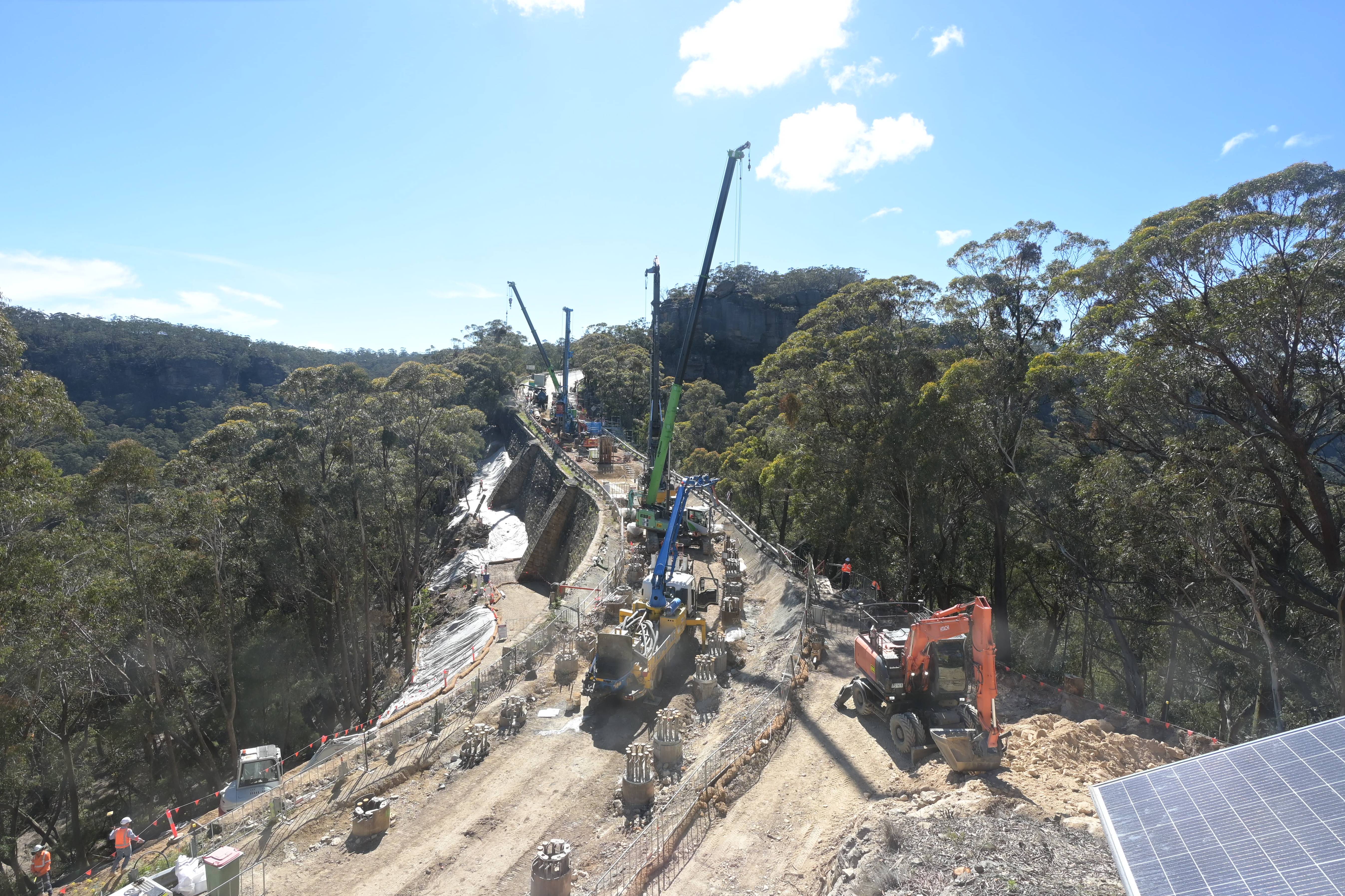
Transport for NSW is carrying out work at Victoria Pass to reinstate this section of the Great Western Highway and reconnect the Blue Mountains with the Central West. While the work is underway, the…
-33.5821, 150.2315
Details OpenStreetMap Source (Data © Transport for NSW (Live Traffic NSW).)


Also in
Postcodes: 2847, 2845, 2846, 2790, 2849, 2786
Suburbs: Lithgow, Portland (NSW), Bowenfels, Wallerawang, South Bowenfels, Marrangaroo