4850 · postcode
Needs action
No Emergency Warnings or Watch and Act alerts right now.
Show map of 4850about 20 KB · loads only when opened▾ Hide map
Map preview · about 20 KB · © OpenStreetMap
Current items by layer
- Fire1No warnings
- Roads1No warnings+4 planned or other
- Power outages7 planned or otherNo warnings
- Other6No warnings
Some other sources for Queensland aren't on this page yet, so this list may be incomplete
Nothing current for Burn areas or Earthquakes.
Live flood data for Queensland isn't available here yet
Live weather data for Queensland isn't available here yet
Live water supply data for Queensland isn't available here yet
Live algal blooms data for Queensland isn't available here yet
Live dams data for Queensland isn't available here yet
Live sharksmart data for Queensland isn't available here yet
Fire 1
Bushfire · PatrolledFire Vegetation — Forrest BeachForrest Beach · QLD ·
Show map of Fire Vegetation — Forrest Beachabout 20 KB · loads only when opened▾ Hide map
Map preview · about 20 KB · © OpenStreetMap
Incident type: FIRE VEGETATION Status: Patrolled Location: Grevillea St & Forrest Beach Rd Locality: FORREST BEACH Region: 1 Northern Region Vehicles assigned: 0 Vehicles on route: 0 Vehicles on…
Updated 27 Oct, 6:06 pm AEST · -18.7049, 146.2924
Details OpenStreetMap Source (© State of Queensland (Queensland Fire Department))
Roads 1
Road damageHazard — Mount Fox Road — Mount FoxMount Fox · QLD ·
Show map of Hazard — Mount Fox Road — Mount Foxabout 20 KB · loads only when opened▾ Hide map
Map preview · about 20 KB · © OpenStreetMap
Event: Hazard Type: Road damage Cause: Rough surface Road: Mount Fox Road Location: Mount Fox Description: Access is limited to vehicles up to a fully loaded Class 5 four-axle truck (maximum GVM of…
Updated 27 Oct, 8:20 am AEST · -18.7486, 145.9300
Details OpenStreetMap Source (Hinchinbrook Local Disaster Coordination Centre)
Other 6
Flood cameraBemerside - Bruce Highway At Seymour River North - NorthQLD
Show map of Bemerside - Bruce Highway At Seymour River North - Northabout 20 KB · loads only when opened▾ Hide map
Map preview · about 20 KB · © OpenStreetMap
Camera: Flood camera location; does not indicate flooding Direction: North Location: Bemerside Information: New images available every 30 minutes between 6am and 6pm. View camera image
-18.5698, 146.1888
Details OpenStreetMap Source (State of Queensland (Department of Transport and Main Roads))
Flood cameraGairloch - Bruce Highway At Gairloch Washaway - SouthQLD
Show map of Gairloch - Bruce Highway At Gairloch Washaway - Southabout 20 KB · loads only when opened▾ Hide map
Map preview · about 20 KB · © OpenStreetMap
Camera: Flood camera location; does not indicate flooding Direction: South Location: Gairloch Information: New images available every 30 minutes between 6am and 6pm. View camera image
-18.6084, 146.1841
Details OpenStreetMap Source (State of Queensland (Department of Transport and Main Roads))
Flood cameraHelens Hill - Bruce Highway At Cattle Creek - SouthQLD
Show map of Helens Hill - Bruce Highway At Cattle Creek - Southabout 20 KB · loads only when opened▾ Hide map
Map preview · about 20 KB · © OpenStreetMap
Camera: Flood camera location; does not indicate flooding Direction: South Location: Helens Hill Information: New images available every 30 minutes between 6am and 6pm. View camera image
-18.7240, 146.1476
Details OpenStreetMap Source (State of Queensland (Department of Transport and Main Roads))
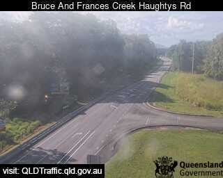
Flood cameraHelens Hill - Bruce Highway At Frances Creek (Haughtys Road) - SouthQLD
Show map of Helens Hill - Bruce Highway At Frances Creek (Haughtys Road) - Southabout 20 KB · loads only when opened▾ Hide map
Map preview · about 20 KB · © OpenStreetMap
Camera: Flood camera location; does not indicate flooding Direction: South Location: Helens Hill Information: New images available every 30 minutes between 6am and 6pm. View camera image
-18.7445, 146.1379
Details OpenStreetMap Source (State of Queensland (Department of Transport and Main Roads))
Flood cameraHelens Hill - Bruce Hwy At Helens Hill (Pombel Road) - SouthQLD
Show map of Helens Hill - Bruce Hwy At Helens Hill (Pombel Road) - Southabout 20 KB · loads only when opened▾ Hide map
Map preview · about 20 KB · © OpenStreetMap
Camera: Flood camera location; does not indicate flooding Direction: South Location: Helens Hill Information: New images available every 30 minutes between 6am and 6pm. View camera image
-18.7561, 146.1355
Details OpenStreetMap Source (State of Queensland (Department of Transport and Main Roads))



Also in
Council areas: Hinchinbrook, Charters Towers
Suburbs: Ingham, Forrest Beach (Qld), Halifax, Lucinda, Trebonne, Blackrock