4660 · postcode
Needs action
No Emergency Warnings or Watch and Act alerts right now.
Show map of 4660about 20 KB · loads only when opened▾ Hide map
Map preview · about 20 KB · © OpenStreetMap
Current items by layer
Some flood sources for Queensland aren't on this page yet, so this list may be incomplete
Some other sources for Queensland aren't on this page yet, so this list may be incomplete
Nothing current for Fire, Burn areas, Earthquakes or Power outages.
Live weather data for Queensland isn't available here yet
Live water supply data for Queensland isn't available here yet
Live algal blooms data for Queensland isn't available here yet
Live dams data for Queensland isn't available here yet
Live sharksmart data for Queensland isn't available here yet
Roads 4
Level: All levels · Emergency Warning · Watch and Act · Advice
Road damageHazard — Bruce Highway — Booyal / Isis CentralBooyal / Isis Central · QLD ·
Show map of Hazard — Bruce Highway — Booyal / Isis Centralabout 20 KB · loads only when opened▾ Hide map
Map preview · about 20 KB · © OpenStreetMap
Event: Hazard Type: Road damage Cause: Rough surface Road: Bruce Highway Location: Booyal / Isis Central Description: Between Kevin Livingston Drive and Booyal Dallarnil Road Impact: All lanes…
Updated 28 Oct, 8:18 pm AEST · -25.2120, 152.1146
Details OpenStreetMap Source (Department of Transport and Main Roads)
Road damageHazard — Bruce Highway — Apple Tree CreekApple Tree Creek · QLD ·
Show map of Hazard — Bruce Highway — Apple Tree Creekabout 20 KB · loads only when opened▾ Hide map
Map preview · about 20 KB · © OpenStreetMap
Event: Hazard Type: Road damage Cause: Rough surface Road: Bruce Highway Location: Apple Tree Creek Description: In the vicinity of Apple Tree Creek Cemetery Impact: All lanes affected Direction: All…
Updated 28 Oct, 8:18 pm AEST · -25.2250, 152.2400
Details OpenStreetMap Source (Department of Transport and Main Roads)
Scheduled roadworkRoadworks — Bruce Highway — Isis RiverIsis River · QLD ·
Show map of Roadworks — Bruce Highway — Isis Riverabout 20 KB · loads only when opened▾ Hide map
Map preview · about 20 KB · © OpenStreetMap
Event: Roadworks Type: Planned roadworks Road: Bruce Highway Location: Isis River Impact: All lanes affected Direction: Both directions Delays: Delays expected (during active hours) Advice: Observe…
Updated 26 Oct, 9:20 pm AEST · -25.2553, 152.3644
Details OpenStreetMap Source (Department of Transport and Main Roads)
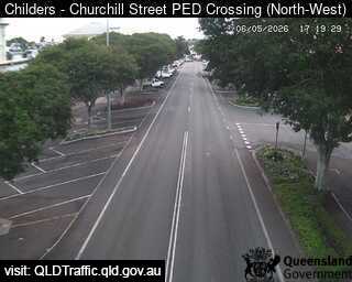
Traffic cameraChilders - Churchill Street Pedestrian Crossing - NorthwestQLD
Show map of Childers - Churchill Street Pedestrian Crossing - Northwestabout 20 KB · loads only when opened▾ Hide map
Map preview · about 20 KB · © OpenStreetMap
Camera: Traffic camera location Direction: SouthWest Location: Childers View camera image
-25.2363, 152.2789
Details OpenStreetMap Source (State of Queensland (Department of Transport and Main Roads))
Also in
Council areas: Bundaberg, Fraser Coast
Suburbs: Childers (Qld), Woodgate, Apple Tree Creek, Redridge, North Isis, Buxton (Qld)